
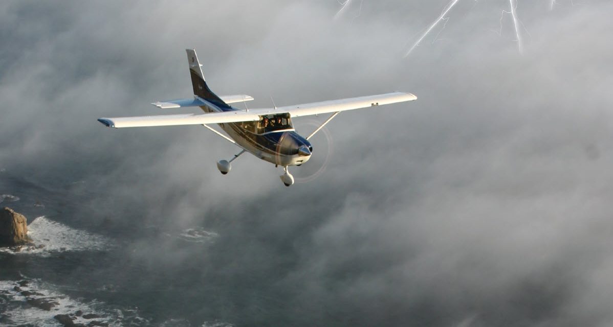
High altitude cuts both ways. The myth is that flying high positions you above the weather and insulates you from the instability of bouncing along in turbulence.
Trouble is, some of the most severe weather may be hiding in (and out of) the clouds above 15,000 feet. Thunderstorms are among the most feared weather phenomena above, spawning furious winds, tornadoes, violent hailstorms, and torrential rain.
Meteorologists suggest there are something like 44,000 thunderstorms a day above the Earth. The dreaded Cbs are weather factories that can generate virtually anything that’s evil in the weather world. A typical three-mile-wide Midwestern storm contains 10 times the power of the Hiroshima atomic bomb, so it’s not surprising that it can spawn tornadoes, lightning, severe turbulence, microbursts, and extreme winds.
That might suggest you should simply park your airplane when thunderstorms are about. If you expect to operate a personal or business aircraft on a regular basis, though, you’ll need to develop strategies for dealing with thunderstorms.
As a delivery pilot of piston singles and twins, turboprops, and jets for the last 35 years, I’ve been subjected to some of the worst thunderstorm weather there is. Many of my ferry flights demand flying across the equator to Australia, South America, or South Africa, and that’s an open invitation for encounters with thunderstorms.
Here’s a short course on handling these monsters.
Keep in mind that many of them are too violent to be negotiated.
1. Altitude
If you’ve travelled in Cb country on airliners, you know that pure jets operate in the altitude regime between FL310 and FL410, and such high flight can impart a feeling of invulnerability. Airliners cruise regularly at FL390, and some captains are convinced they can top anything.
Don’t believe it. Not even Concorde could conquer some thunderstorms.
Fortunately, most of the time, even those of us relegated to the bottom five miles of sky can climb above most weather. Most. That’s because half the Earth’s atmosphere lies below 18,000 feet. Clouds demand moisture in order to form, and that lower half contains about 80 percent of clouds that can make a pilot’s life miserable.
The other 20 percent can still generate problems, especially if you’re flying in places without a choice of alternates. Much of the time on international delivery flights, you either continue to your destination any way you can or reverse course and return to your point of departure.
2. Thunderstorms and Range
Two years ago, I was about four hours out of Honolulu bound for Majuro, Marshall Islands, 2,000 nm toward the bottom of the planet. I was flying a new Cessna Grand Caravan, enjoying a 30-knot push from the reliable trade winds.
The sky had been CAVU since my 6 a.m. departure from PHNL on the trip southwest, and the view straight ahead promised nothing worse than the usual scattered popcorn cumulus, already starting to form in the heat of perpetual summer.
Encouraged by characteristic tailwinds, I’d filed for FL180, pretty tall for a four-ton flying pachyderm loaded another ton over gross with ferry fuel, but I was determined to take maximum advantage of the wind and minimize the fuel cost.
Tiny Johnston Island passed below — the last irregular square mile of land for 1,300 miles until Majuro. Johnston was a top-secret military missile-launch site in the ’60s and ’70s and a storage depot for biological and chemical weapons for 25 years after that. I’d landed there once in a Mirage with a fuel leak on my way back from Japan, and after the military had determined my emergency was real, they’d been very friendly but also very formal, suggesting I needed to fi x my problem and leave — immediately. I replaced some cracked tubing to the ferry tank, refiled my flight plan, lied about my fuel reserve, and struggled into Kauai late that night with nine gallons remaining.
In the Caravan, speed continued to increase to 190 knots, about 40 knots quicker than normal. I could get used to this, I thought. Clear skies, sunshine, and even a push. Just need to buy a little oxygen in Guam.
God stopped smiling about an hour southwest of Johnston. Building cumulus began to muscle the sky, and I could see some clouds climbing toward the high blue, far above my level. I couldn’t even guess at the tops, but they were turning from white to grey to black, already 10,000 feet above me and rapidly spreading from horizon to horizon.
3. The Intertropical Convergence Zone
Thunderstorms might seem unlikely over the benign Pacific, but in this case, the dreaded Intertropical Convergence Zone (inevitably the ITCZ), where weather systems from the northern and southern hemisphere collide, was at it again, roiling the atmosphere near the equator and making life miserable for those few hardy souls/silly fools flying the Pacific without the benefit of at least two turbine engines on the wings, stand-up headroom in the cabin, a sit-down potty, a hot meal, and a flight attendant to serve it.
The weather ahead was becoming more violent as I approached, with cloud-to-cloud lightning beginning to flash across the sky, brilliant strobes of light one minute and semi-muted illumination inside clouds the next. Continued flight at 18,000 was no longer an option.
Low was the only way to go. Trouble was, how low? I called San Francisco Long Range on HF, advised them of my problem and they essentially replied with ATC’s equivalent of “Whatever and advise.” Apparently, there weren’t any other idiots droning around at low level over the Central Pacific 1,000 miles from the nearest land.
How low started off at 12,000 feet, then dropped to 6,000 feet, and finally settled on 1,000 feet in heavy rain but minimal turbulence. My tailwind evaporated, of course, and I plugged along for another seven hours, bouncing through the chop at FL 010, happy that I had a reliable PT6 out front. The landing in Majuro was anticlimactic, but I wound up burning almost exactly what I’d flight planned, 563 gallons.
4. Height Considerations
The bad news about thunderstorms in the flight levels or below is that pilots of single-engine piston and turbine equipment probably won’t be able to top them. Thunderstorm tops are lower at the higher northern or southern latitudes than at the equator, one reason ferry pilots have more experience than they’d like with the type. Tops for a fully developed boomer above North America are generally 35,000 feet.
Without pressurization, “my” Caravan hardly qualified as a flight level airplane anyway, though the type can be coaxed above 18,000 feet when there’s a need. Even Mirages, Meridians, TBMs, PC-12s, and the like may be challenged to top a typical heavy-breathing Cb, especially one inspired by orographic lift or rotor clouds generated by mountain wave conditions off high terrain (or in my case, the ITCZ).
Never mind that the pressurization systems in most singles aren’t designed for altitudes above 25,000 feet, the price of RVSM certification is so steep, most piston and turboprop singles aren’t approved for operation above FL280.
5. Clear Air Turbulence
Even if you can top a thunderstorm, you may not want to. The clear air directly above a not-so-tall cumulo-nimbus may offer some of the roughest air you’ll ever encounter. Convective activity may continue high over the visible moisture, and you may encounter a phenomenon simply referred to by pilots as Clear Air Turbulence (CAT).
Threading your way through the clouds may be a sucker’s bet, anyway. What might look like a blue hole from 20 miles away can close up faster than you’d believe. Flying an Aerostar 700 across the Gulf of Mexico 20 years ago, I flew by a developing Cb with clouds boiling higher at what must have been 1,000 fpm. I circled it for a few minutes, amazed at its rapid development.
Even if you do make it through a hole in the weather, you may find you’ve been seduced into worse conditions on the other side, or you may discover that the clouds only ramp higher.
6. Diverting
Diverting left or right is always a possibility, especially if your t’storm is a single cell and not part of a front. If you have a choice in the northern hemisphere, consider an off-course deviation to the right first. You may actually pick up a little tailwind (rotation in a low is counterclockwise). Even the largest single-cell thunderstorms are rarely more than 30 miles across, so the earlier you divert, the better.
I once delivered a Riley Turbine Eagle, a Cessna 421 converted to PT6 turboprops, from Carlsbad, California, to Capetown, South Africa, in the middle of their summer. Flying at FL270 for practically the entire trip, I dodged thunderstorms from the moment I made landfall over Africa’s Moroccan Sahara to my final landing. Air traffic control in that part of the world is mostly ad-libbed anyway, and no one seemed to mind if I plotted my own path around the storms. I learned to initiate course deviations as early as possible to avoid extending the total leg and cutting into my reserves.
7. Studying The Big Storms
South of Cameroon, the combination of humid triple-canopy rain forest and an ITCZ fed from north and south by often violent weather systems results in what some regard as Earth’s most spectacular and consistent thunderstorm zone. Meteorologists travel to Gabon and Congo from all over the world to study the development of Cbs along the West African equator. The lightning displays are among the most impressive fireworks you’ll ever witness.
Departing Libreville, Gabon, I climbed to FL270 and quickly realized I had no chance of topping the clouds. The only choice was to sidestep far offshore and parallel the coast straight south, toward Namibia. Congo, Zaire, and Angola weren’t especially friendly to the U.S. in those days. Sixty miles off the coast, I was finally able to turn back south toward my next stop at Windhoek, Namibia.
8. Icing Ahead
Thunderstorm encounters above 20,000 feet don’t normally present much of an icing hazard, as it’s usually too cold for ice to form, though I’ve seen thin layers of frost materialize on the windshield. Conventional rime or clear ice aren’t the only hazards, however.
The airlines generally suggest their flight crews remain at least 20 miles from the nearest active thunderstorm, not only for turbulence avoidance but because of potential hail. Even if you’re flying in what appears to be clear air and sunshine several miles from an active Cb, hail can assault the airplane and do thousands of dollars’ damage in a few seconds.
9. Lightning Concerns
Perhaps surprisingly, lightning — the most dramatic manifestation of thunderstorms — winds up being one of the more benign threats. In contrast to the tremendous power of lightning (a typical ground strike can carry as much as one billion volts), the consequences of a strike on an aircraft are usually relatively harmless, because an aluminum fuselage is an excellent conductor, channeling the energy harmlessly through the aircraft’s outer skin. It’s estimated that virtually every commercial airliner is struck at least once a year, and hardly any suffer major consequences to people or systems.
The greatest threat of a lightning strike is against a fuel vent to a nearly empty tank loaded with explosive vapor. Serious lightning accidents are so rare that the last verified instance of a strike causing an accident was in 1976, a Boeing 747 freighter in Spain. Composite airplanes have less natural resistance to lightning damage, and therefore are fitted with an embedded layer of conductive fibers or metal screening material to channel the charge through the skin and back out into the sky.
General aviation aircraft aren’t immune from lightning strikes, but their exposure is minimal, as they typically operate at lower altitudes and rarely in close proximity to thunderstorms. Also, personal aircraft are usually smaller and less liable to attract or generate lightning. Large corporate aircraft that operate in the airline environment are more likely to suffer damage.
These days, many business aircraft can imitate the performance capabilities of airliners. Single-engine turboprops offer speed and range comparable to commuter airlines and can operate above the weather — most of the time. It’s important to remember, however, that few aircraft can count on topping every storm.
10. Where Are The Tops?
In his book “Operation Overflight,” U2 pilot Francis Gary Powers recalled a flight above the Middle East when he was staring at the top of a thunderstorm. Powers wrote that he was looking “way up” and could see the storm continuing to build far above him — and Powers was at 80,000 feet.


