
Good flight planning begins with a mindset, and that mindset is to always fly proactively, and never reactively. Being surprised by something that could have been known prior to takeoff is an example of flying reactively. Flying proactively is researching every aspect of your flight so that, with your hands full flying the airplane, you never have to look for information that could have been gathered before departure. Preparing for a flight is not an option, it is a regulation.
FAR 91.103 states, “Each pilot in command shall, before beginning a flight, become familiar with all available information concerning that flight.” Adhering to the tenets of good flight planning will result in a flight that goes smoothly with few, if any, glitches. So, let’s get started on proactively planning for a typical VFR cross-country flight.
While this tutorial is about preflight planning a VFR flight, everything presented here also applies to an IFR flight. So, instrument pilots take note! Also, all flight planning in this tutorial will be done using the ForeFlight app.
Let the planning begin!
It is July 9, 2019, and we are preparing to fly from the Jake Arner Memorial Airport (22N) in Lehighton, Pennsylvania, to the Sidney Municipal Airport (N23) in Sidney, New York. It will be a day VFR flight in a typical single-engine airplane.
Since Jake Arner Memorial Airport is our home base, we are already familiar with operations there. But even so, some research before departure is still in order. This includes checking NOTAMs, the current weather, forecast weather, winds aloft, whether a TFR exists, and for AIRMETs or SIGMETs.
The result of our investigation is that everything looks good for our departure from 22N. However, we have never been to Sidney, New York, so some research is in order.
The first step is to log onto ForeFlight and open the Airports tab. In the search bar, type in N23, and pull up the airport data. Figure 1 is what it shows. Keep in mind the date of our proposed flight is July 9, 2019.
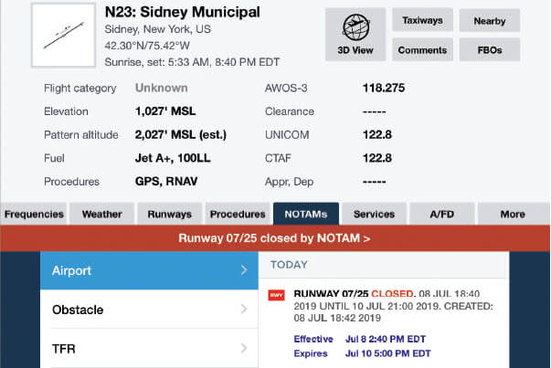
Runways 07 and 25, the only runways at Sidney, are both closed according to the NOTAM, which means we cannot make this flight.
Had we flown reactively, and simply taken off without doing our homework, we would have been greeted by a big yellow X at the end of each runway, and the need to divert to another airport, or back to Jake Arner. It is critically important to fly proactively and do some research before slipping the surly bonds of Earth.
Let’s try again
Since flying to Sidney is no longer an option, we have decided to fly from the Jake Arner Memorial Airport, to the Cherry Ridge Airport (N30) in Honesville, Pennsylvania, for lunch at the airport restaurant. Again, we have never been to Cherry Ridge, so in the interest of being proactive, we will need to do some homework.
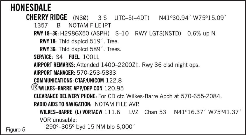
On the ForeFlight Airports tab, type N30 in the search window and the airport information will appear.
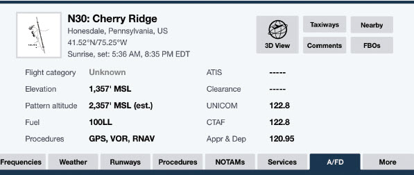
The next order of business is to record all pertinent information concerning N30 on a 3-by-5 index card, or something similar, which will be referred to as an airport data card. This is done so we will have everything we need to know about Cherry Ridge concentrated in one place. Once the data card is complete, it is a good idea to keep it readily available in the cockpit. I keep mine clipped to my kneeboard.
From the Airports tab, record the airport elevation, traffic pattern altitude, the CTAF/Unicom frequency, and the approach/departure frequency so we can obtain flight following on departure. Note that Cherry Ridge has no ASOS or AWOS, so local weather is not available. Also, as our research continues, more information may be added to our airport data card.
Sometimes, important information can only be found under the Comments tab, so let’s see what it has to say about the Cherry Ridge Airport.
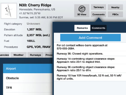
The second comment says that Runway 36 is closed to night takeoffs and landings. While our flight will be conducted in daylight, this could be a factor on future flights, if they are conducted at night. Place a note on your airport data card that night operations on Runway 36 are not authorized.

To get some perspective on our planned destination, a check of the airport diagram is in order. Note that both runways have substantially displaced thresholds. When a threshold is displaced, it is usually because obstacles penetrate the normal landing approach path. This is a clue that we need to be cautious operating to and from Cherry Ridge as terrain or trees exist close to both runways.
The next area of interest is the Airport/Facility Directory, or AFD. Tap on the AFD icon and scroll down until you see Honesdale.
First, note that the prohibition on night operations on Runway 36 is stated under Airport Remarks. In addition, there is a red flag among the otherwise unremarkable data in the AFD, and that concerns the usable runway length for landing.
Doing the math
To determine how much usable runway is available for landing on Runway 18, subtract the displaced threshold of 519 feet from the total runway length of 2,986 feet, and note that only 2,467 feet is available. On Runway 36, subtract 589 feet from 2,986 and note that we will only have 2,397 feet available for landing. This should prompt us to calculate a landing performance problem. It is also a clue that the obstacles off the end of Runway 36 are taller, or closer in, than for Runway 18.
And while the entire 2,986 feet is available for takeoff, the displaced thresholds mean a takeoff performance calculation should be made using a 50-foot obstacle off the departure end of both runways.
Drawing the line
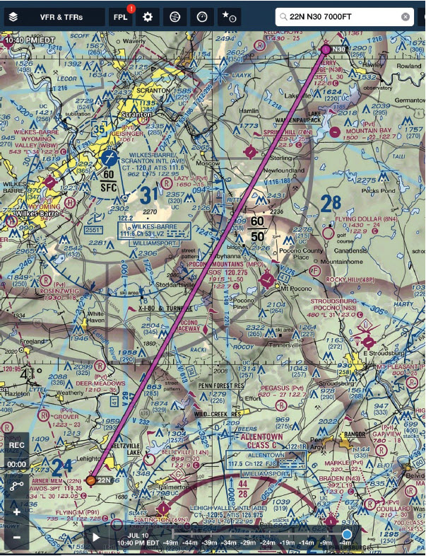
Let’s now look at our proposed route, which will be flown at 5,500 feet, and check for TFRs or other restrictions such as Class B, C, D, or military airspace. Wilkes-Barre Scranton (KAVP) is a terminal radar service area (TRSA) that exists on our route between 5,000 and 6,000 in the southeast sector and 3,900-6,000 feet in the northeast sector. All that is legally required to fly through the TRSA along our route is to be squawking 1200. However, contacting KAVP Approach control on 120.95 and asking for flight following would be a good technique.
What doing our homework has revealed
As a result of proactive flight planning, we have discovered the following information in preparation for our flight.
- Our first proposed flight to Sidney, New York, could not be flown as our research found that the airport was closed.
- The runways for landing at Cherry Ridge are much shorter than what appears on the airport diagram due to displaced thresholds, and that a landing performance calculation should be made.
- There are trees or other obstacles in close proximity to both runways at Cherry Ridge, indicating caution is needed especially on Runway 36.
- Night takeoffs and landings from Runway 36 at Cherry Ridge are prohibited.
- That due to trees in the immediate vicinity of the runway, a takeoff performance calculation over a 50-foot obstacle should be made for our return flight.
What VFR pilots need to know about night takeoffs
You may have noted on the bottom of my airport data card the letters ODP, highlighted in yellow. This stands for obstacle departure procedure, and it refers to special routes instrument pilots fly in IMC to avoid obstacles in the departure path.
While ODPs are normally the domain of IFR departures, they absolutely apply to night VFR departures as well. After all, not being able to see high terrain is not limited to it being obscured by clouds since you may not be able to see the same terrain at night. More importantly, if an instrument pilot is not supposed to make any turns until reaching a safe altitude in IMC, why wouldn’t a VFR pilot want to do the same thing in VMC at night?
With this in mind I am going to take those readers who are non-instrument rated pilots someplace they may never have been before — the instrument approach chart book. I know the word “approach” seems counterintuitive for takeoffs, but be patient, as relevancy can be proven!
Here are the simple steps VFR pilots can take to see if an ODP for their departure airport exists, and if so, what the procedure is. Keep in mind that flying an ODP is optional for the VFR pilot. However, if you elect to fly an obstacle departure procedure, climb to the prescribed altitude at Vy, the best rate of climb speed, and not at a leisurely cruise climb speed.
- In ForeFlight, open the Plates tab.
- Type the airport identifier in the search window.
- A dropdown menu will appear. Touch the Takeoff Minimums icon.
- Scroll sideways until the name of the city nearest the departure airport, or the airport name, appears. If your airport does not appear, an ODP for your departure airport does not exist.
- Look for a heading to fly and altitude to climb to before turning. All other information is for reference only. If there is no mention of a heading or altitude, an ODP does not apply for a VFR departure.
Let’s see if Jake Arner Memorial Airport has an ODP
In order for an airport to have a published ODP, it must first have an instrument approach, and Jake Arner has two. I have personally flown from the Jake Arner Memorial Airport and know that it is situated in a valley with high terrain to the north and south of the runway.
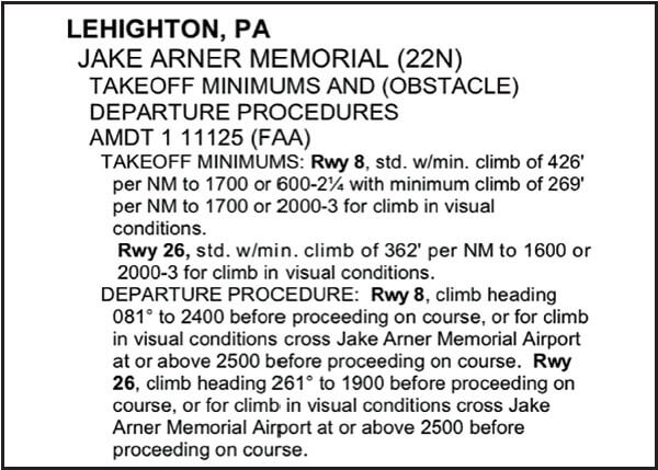
Following the steps outlined above, you can see that the Jake Arner Memorial Airport does have an ODP. For Runway 08 the ODP is to climb on heading 081 degrees to 2,400 feet MSL before making any turns. For Runway 26, climb heading 261 degrees to 1,900 feet MSL before making any turns.
The numbers don’t lie
Since the field elevation at Jake Arner is 534 feet, a climb of 1,866 feet AGL is required in order to clear the terrain after departing Runway 08 and before turning. To clear the terrain on Runway 26 requires a climb of 1,366 feet AGL before a turn can safely be made. With these numbers in mind, it’s clear that taking off VFR at night and making an immediate turn to the north or south may result in controlled flight into the terrain if the ODP is not followed.
A little unsupervised solo
As an exercise for my readership, use the above methods to find the ODP for Cherry Ridge (N30), and determine what it entails.
The objective of this tutorial is to validate the wisdom of proactive flight planning. It was also my intent to emphasize the benefits of researching every aspect of a VFR cross-country flight. I also hope that the text has exposed the dangers of flying reactively by simply taking off and flying to one’s destination. As always, feel free to contact me personally with comments, corrections, or just to yell at me.


