

The goal of professional flight planning begins with a mindset. This mindset is to never be surprised by something that could have been known before departure.
Good instrument pilots are familiar with all information relevant to the flight — such as frequencies, weather, departure runway, NOTAMS, obstacle departure procedures, arrival instrument approaches, etc. — and have that information easily available in the cockpit.
Thorough flight planning means you are flying proactively, not reactively. Searching for who to call for your IFR clearance at an uncontrolled field after engine start is the very essence of flying reactively. With this in mind, let’s get started on planning an IFR flight.
Before we begin
Regardless of the certificates held, every pilot who flies in the IFR system is, for all practical purposes, a professional pilot. When the general aviation pilot files an IFR flight plan, he or she will be flying in the same airspace, under the same rules, and communicating with the same air traffic controllers as airline pilots. And to this end, the instrument rated general aviation pilot should set a goal to fly as the professional pilot does, and it all begins with flight planning.
Start with the basics
The flight we will be planning departs from Penn Valley Airport (KSEG) in Selinsgrove, Pennsylvania, to Allegheny County Airport (KAGC) near Pittsburgh. To keep this discussion as operationally oriented as possible, we will plan an actual IFR flight using current weather, NOTAMS, winds aloft, and fuel burn for March 22, 2020.
We will be flying a single-engine airplane that burns 15 gph, similar to a Cessna 210 or a Piper Saratoga. It will be a night takeoff, with a proposed takeoff time of 8 p.m. EDT (0100 Zulu). As a professional pilot, I flight plan by asking myself the following questions.
1. What route will I file?
I always file the route I will most likely be cleared to fly, rather than the one I want. Getting a route totally different than the one filed means most prefight planning, such as fuel calculations, will have to be refigured with the possibility that more fuel will need to be added to be legal under IFR.
I use FltPlan.com for determining what routes to file, flight logs, fuel burn, altitude to fly, minimum fuel required, alternates, GPS RAIM status, and to file my flight plan. I then switch to ForeFlight for weather, NOTAMS, SIGMET, AIRMETS, airport data, approach charts, and other supporting information.
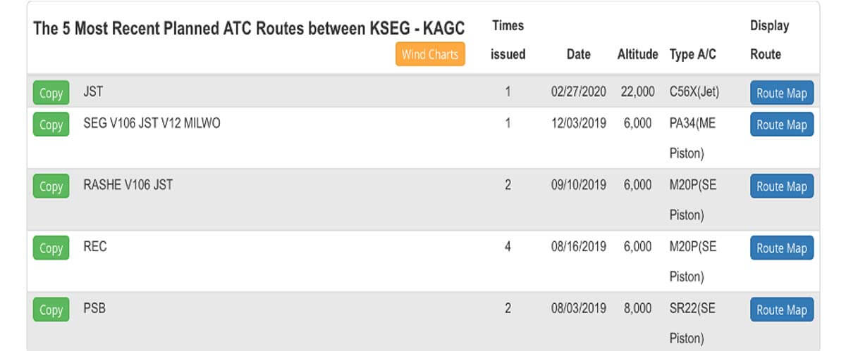
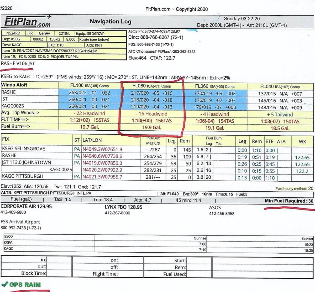
Logging onto FltPlan.com, I look for a route previously issued to an airplane similar to the one I am flying. The route I would file for this flight was issued to a single-engine Mooney, which is direct RASHE V106 JST direct KAGC (see Figure 1). I then make a copy of the nav log and keep it handy for future reference.
2. How will I get my IFR clearance on the ground at the uncontrolled KSEG?
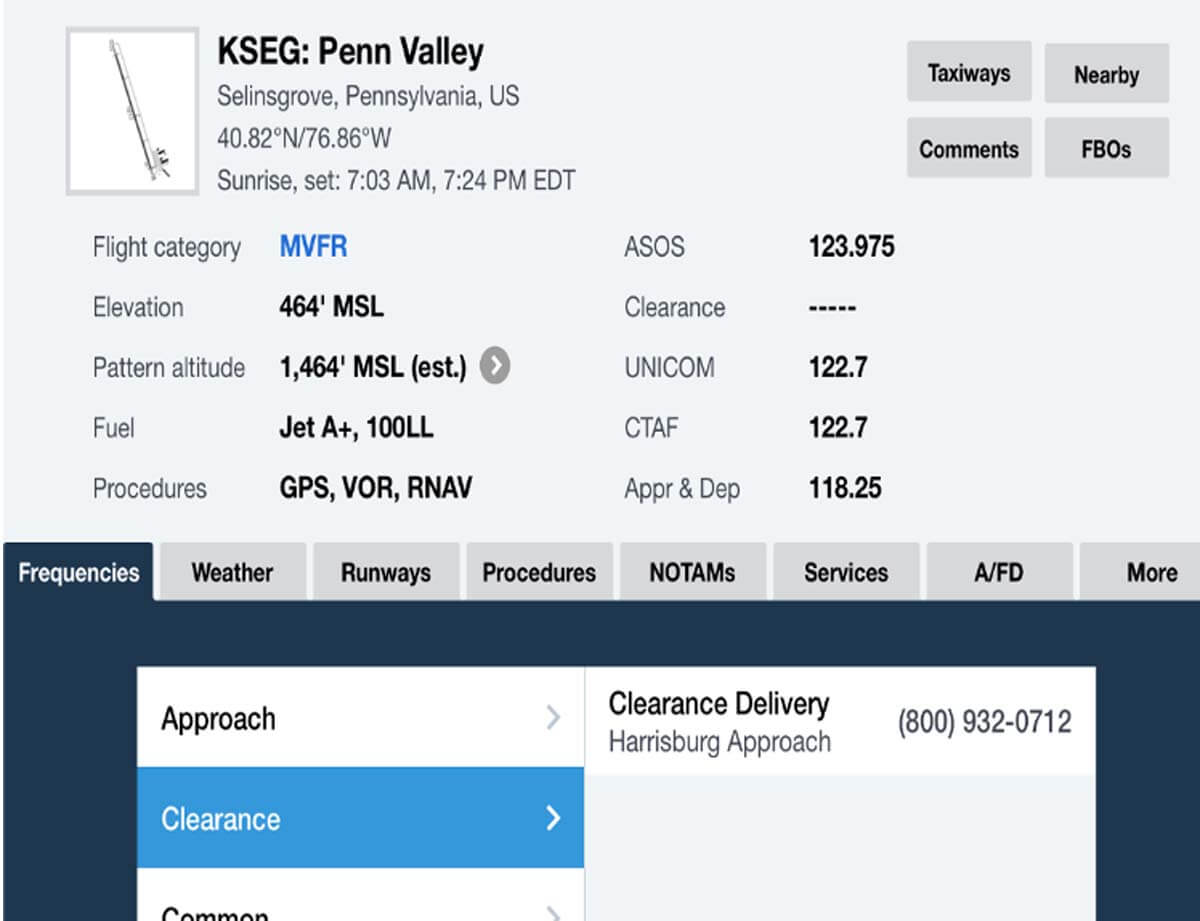
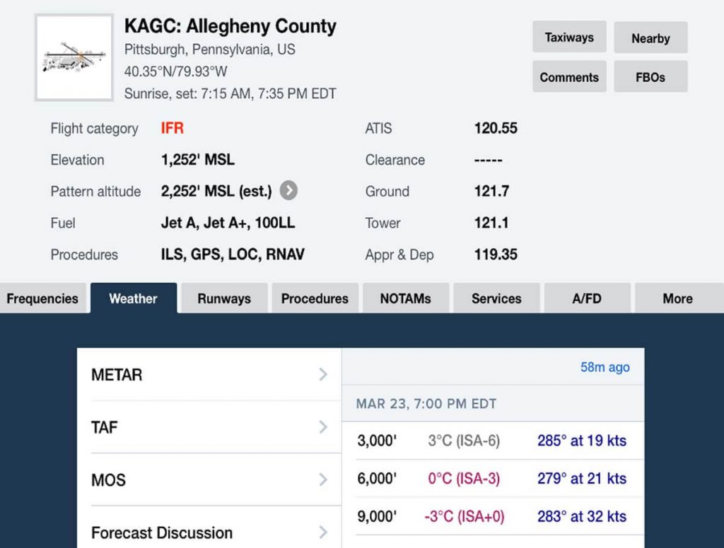
Switching to ForeFlight, I reference the Airports tab (see Figure 2) and note a phone number for Harrisburg approach control. Since there is no VHF frequency directly to Harrisburg approach, I will have to get my clearance and IFR release via cellphone.
3. Based on the ASOS weather, what runway will I depart from at KSEG?
The ASOS shows winds from 100 degrees at 8 knots meaning I will depart on Runway 17.
4. Is there an obstacle departure procedure for Runway 17?
In ForeFlight, I tap the Plates tab for KSEG, select Takeoff Minimums, then scroll to the right until I find Penn Valley (see Figure 3). There is an ODP for Runway 17, which is to make a climbing right turn direct to the SEG VOR before turning on course.
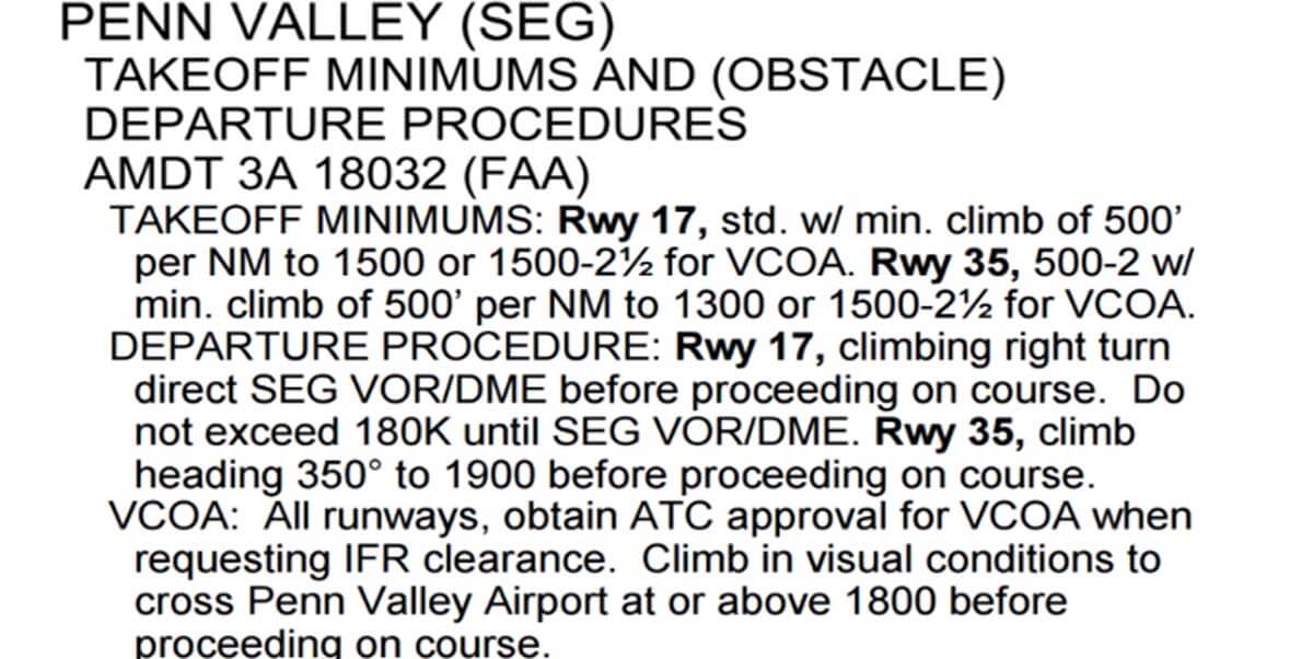
I also note that the SEG VOR is not on the route I filed. Assuming I get cleared as filed, I will need to tell the controller who issues my IFR clearance that I will be flying the ODP to the SEG VOR before going directly to the first fix on my route, which is RASHE. Note: Do not fly ODPs at controlled fields where radar is in use.
5. What altitude will I file for?
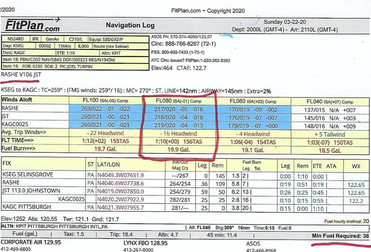
Refer to the flight log from FltPlan.com and note the four suggested altitudes. For this flight I accepted the one for 8,000 feet, which I then filed. Even though lower is more efficient, it is a night flight over rough terrain and for added safety, I prefer to have a little more altitude in case of engine failure. This is another example of proactive flight planning.
6. What time will I be arriving at KAGC?
The flight log shows a planned flight time of 1 hour, 10 minutes. Departing at 0100Z, I should arrive at KAGC at approximately 0210Z.
7. What is the weather forecast 0210Z at my destination?
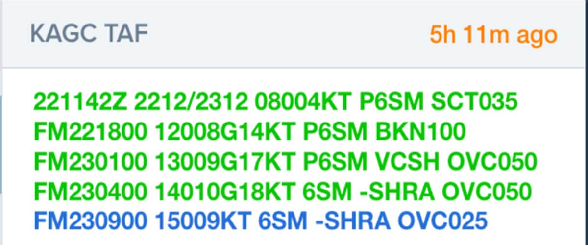
Looking at the TAF in ForeFlight (see Figure 5) for a 0210Z arrival at KAGC, the forecast weather between 0100Z and 0400Z is for winds 130 degrees at 9 knots gusting to 17 knots, greater than 6 miles visibility, showers in the vicinity, and a ceiling of 5,000 overcast.
8. Will I need to file an IFR alternate?
An alternate is not legally required; however, I would file KPIT as my alternate anyway since things other than weather can require a diversion. Crosswinds out of limits, power failure at the destination airport, an aircraft accident on the field, or a security issue are just a few things other than weather that can cause a diversion. Flying proactively means planning for the unexpected!
9. What is the minimum fuel required to legally take off?
Looking at the flight log, at my cruise altitude of 8,000 feet, and based on 15 gph, the minimum fuel to fly to KAGC, to the alternate, and a buffer of 45 minutes is 36 gallons (see Figure 6, underlined in red). I will need at least this amount on board to be legal.
10. Will I be able to navigate using GPS?
At the bottom left corner of the flight log is a green icon with a check mark indicating that GPS RAIM is normal.
11. Based on the TAF (see Figure 6), and an arrival at 0210Z, what approach can I expect, and will I have landing minimums?
The forecast wind will be from 130 degrees, so I will most likely be flying the ILS Runway 10 approach, and weather should be well above landing minimums.
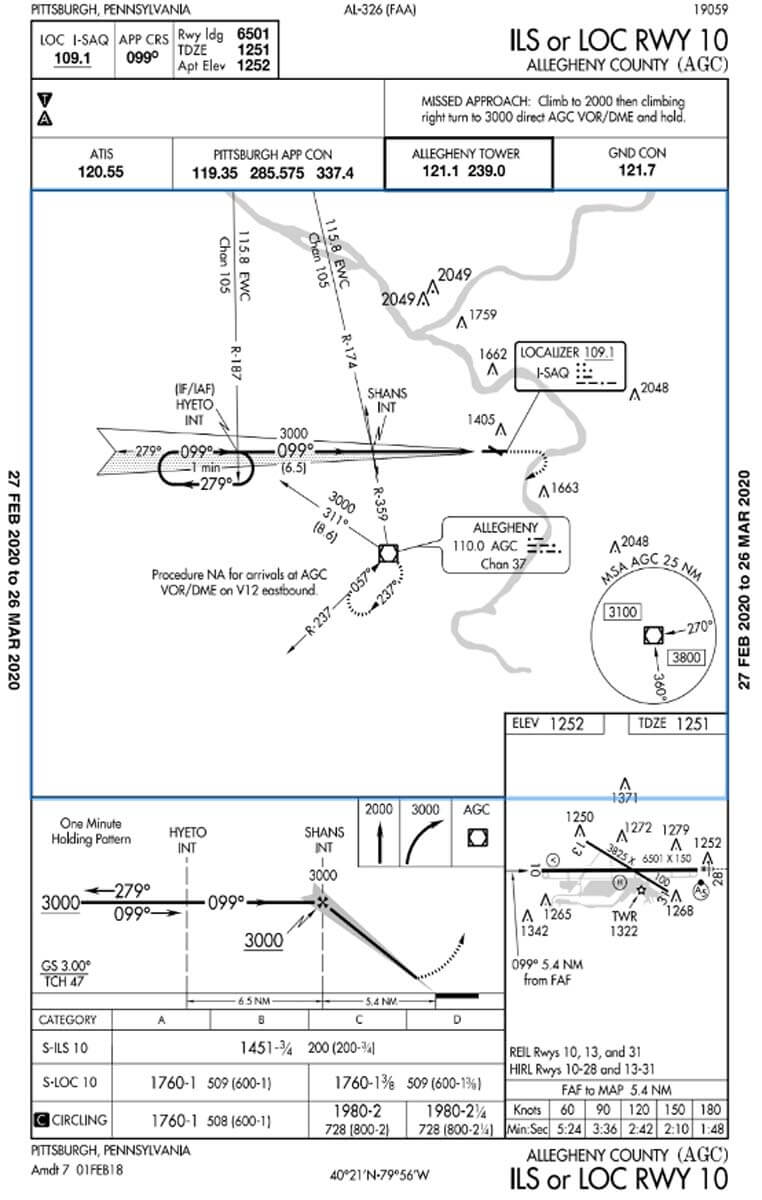
12. Is there anything unusual on the ILS to Runway 10 approach chart?
A review of the approach chart for the ILS Runway 10 (see Figure 7) reveals nothing unusual. Minimums are 200 feet and a visibility of 3/4 mile.
13. Are there any NOTAMS at KSEG or KAGC that will affect my flight?
On ForeFlight, under the Airports tab, a check of the NOTAMS shows nothing that will impact my flight.
14. Are there any SIGMET or AIRMETS?
Again, ForeFlight shows none for my route.
15. What is the freezing level, and will I encounter icing?
A check of the icing probability chart, and referencing AIRMETS and SIGMETS shows no icing at my proposed cruise altitude of 8,000 feet. Also, checking the temperature on the winds aloft matrix (see Figure 8) for the KAGC area, I note the freezing level is at 6,000 feet. This assures me that that if ice is encountered at 8,000 feet, I can escape the ice by descending as I will
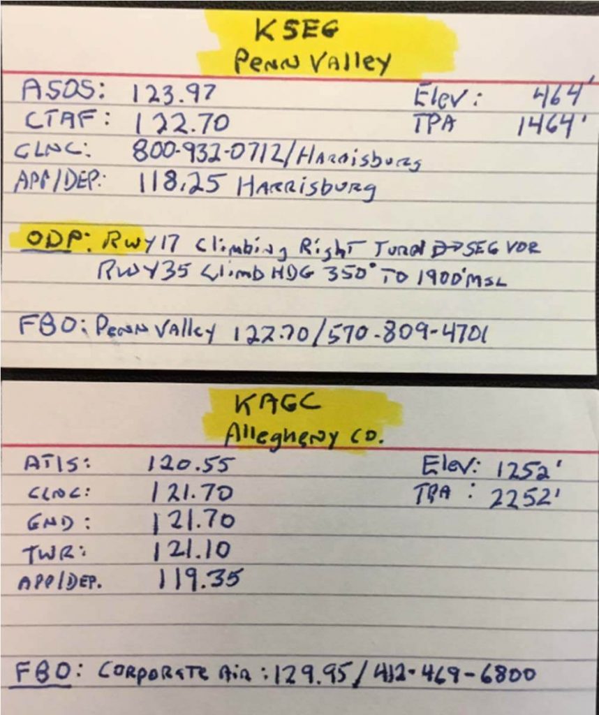
have a buffer of warmer air at and below 6,000 feet as a safety net. Knowing that I have this safety net is yet another example of flying proactively. One final step is to make an airport data card (see Figure 9) or other venue to record all pertinent information about KSEG and KAGC.
Conclusion
Flight planning professionally, and hence proactively, requires that these questions, at a minimum, be answered. Doing one’s homework before going out into the wild gray yonder of instrument flying will result in a flight that has few, if any, surprises or glitches.
As always, it is my sincerest hope that this tutorial will help the instrument pilot improve the safety, and professionalism of his or her flying endeavors.


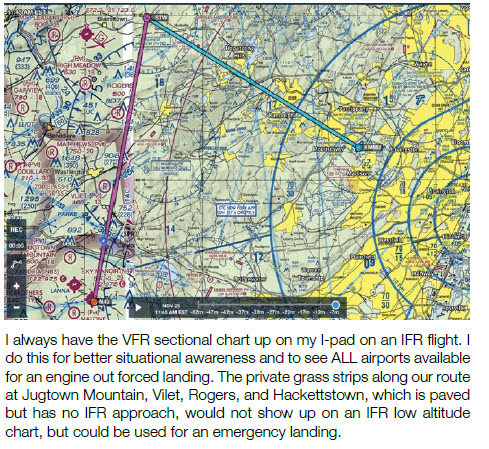

