
Don’t Let Rough Air Ruin the Trip for You and Your Passengers
Producer Dave Jackson and I were flying a borrowed Skyhawk above Maui, Hawaii, working on a video travelogue piece I’d written called “Flying the Islands of Paradise” for the ’80s TV series, “ABC’s Wide World of Flying.” We were shooting B-roll footage, bouncing through light turbulence over Lahaina – not ideal conditions for Dave, who was trying to balance a heavy Sony Betacam on his shoulder.
Suddenly, without warning, the Skyhawk flew through a violent downdraft like none other I’ve felt in an airplane. Dave’s Betacam slammed into the roof so hard that I was surprised it didn’t come apart. As it turned out, the camera survived undamaged. The headliner, however, didn’t.
The turbulence was only one jolt, but I knew the airplane had to have been damaged. As an aerobatic pilot, I’ve experienced up to seven Gs, and I knew our instantaneous shock had been at least that strong.
Of course, I was wrong. I flew the 172 back to Kahului Airport, landed as gently as I could, and we climbed out to check the little Cessna for warped skins, even removing some access panels. Amazingly, there wasn’t a wrinkle anywhere. There’d been no damage.
If you fly with a G-meter on the panel through even the roughest air, you’ll discover that turbulence almost never exceeds 2.0-2.5 Gs, much less the 3.8 G limit of the normal category. Damage from turbulence is extremely rare, no matter what the size or structure of the aircraft.
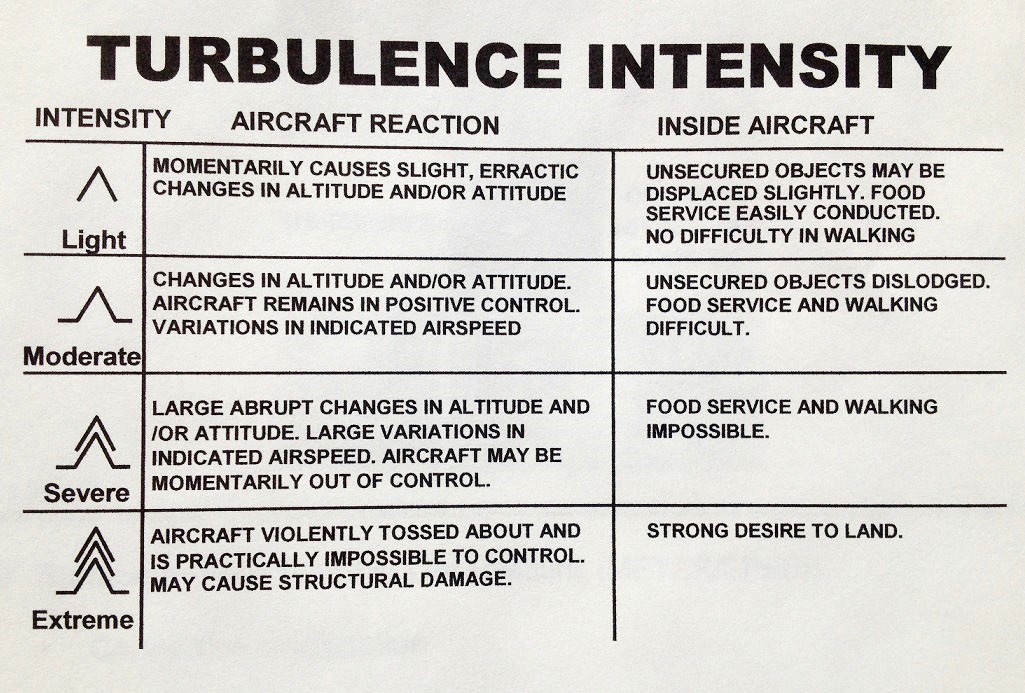
Technically, turbulence is categorized as light, moderate, severe, or extreme, and the only category that’s liable to cause damage to an aircraft is the worst one, extreme. Encountering that level is highly unlikely unless you fly straight into the side of a fully-developed thunderstorm.
Sadly, that does happen, and it’s not always the pilot’s fault, whether he’s one of the world’s best aviators or an amateur. Back in April, 2006, we lost famous X-15 test pilot Scott Crossfield when his Cessna 210A was torn apart in extreme turbulence over northern Georgia. Scotty was on an IFR flight plan and talking to controllers at the time of the accident.
One of the most insidious forms of turbulence is also perhaps the rarest, Clear Air Turbulence, inevitably known by its acronym, CAT. As the name implies, CAT is the most difficult to predict because it’s invisible, and there’s currently no electronic warning possible.
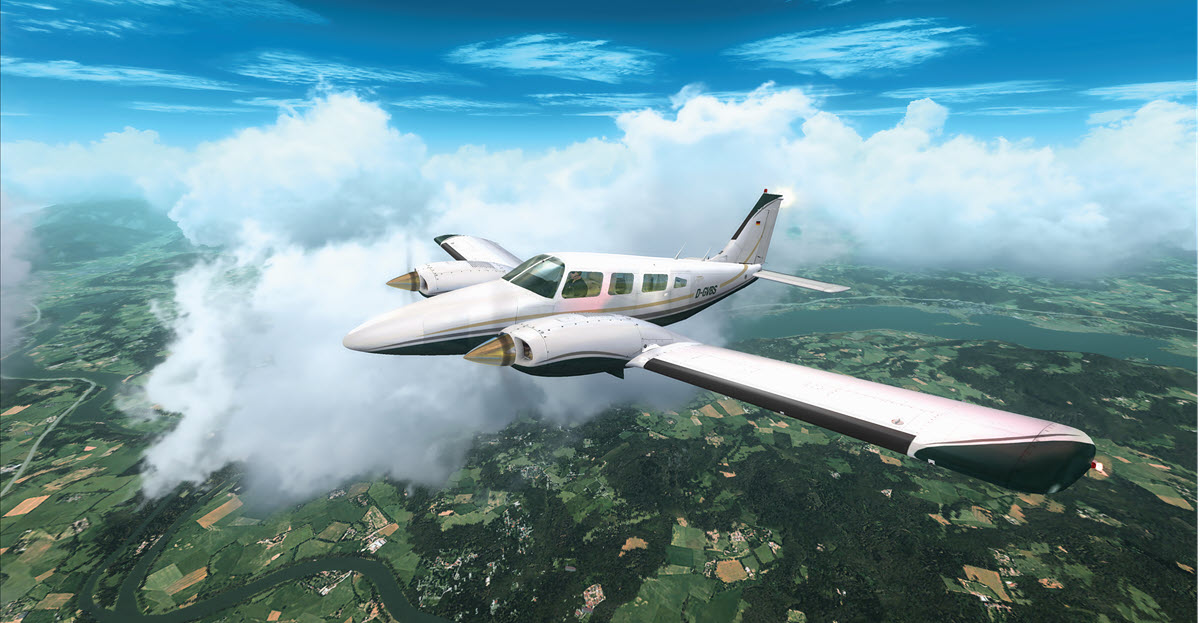
Clear Air Turbulence is thought to be generated by shifting jet streams, so by definition, it’s primarily a medium-to high-altitude phenomenon, usually experienced above 18,000 feet. Problem is, the jet stream can sometimes dip well below 18,000 feet, and that makes it a threat for twin-engine piston and single-engine turboprop aircraft.
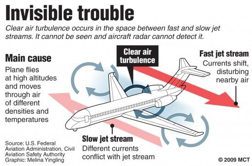
Until recently, the only method of approximating the location of CAT was to track the edges of the jet stream where the wind shears dramatically in velocity. A number of investigations into predicting clear air turbulence have been launched by prestigious agencies such as NASA, MIT, NOAA, and the National Center for Atmospheric Research in Boulder, Colorado. In addition to studying shear zones at the edges of jet streams, scientists are examining gravity waves and a variety of other methods of detecting CAT.
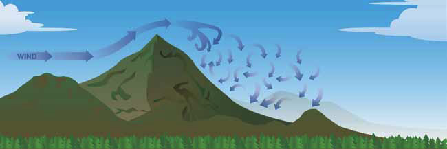
Two factors that generate more turbulence than any others are mountain waves of air curling up from the terrain below and thermal activity off the hot Earth. Single-engine turboprops’ high cruise altitude tends to help insulate them from both factors. There are few mountains tall enough to generate severe turbulence at our normal cruising heights. There’s nothing in North America above 20,500 feet (Alaska’s Denali/McKinley) and nothing in the rest of the Western Hemisphere above 23,000 feet (Cerro Aconcagua east of Santiago, Chile). Similarly, thermal turbulence tends to dissipate with altitude.
Mountain wave activity is similar to water flowing over rocks in a stream (See Figure 1, Page 38). Such atmospheric waves may tumble and roll, subjecting aircraft to severe turbulence, sometimes as much as 10,000 feet above the terrain and as far as 100 miles downwind from the mountains. Since the prevailing winds over the Rockies are usually westerlies, this can mean rough air far out over the flatlands of eastern Colorado where you’d least expect it. The swell of rising air may also arc far above the highest peaks. The jagged Rockies are infamous for such activity; that’s one reason many private turboprops and jets without the ability to climb above FL350 sometimes prefer the southern east-west route over northern New Mexico.
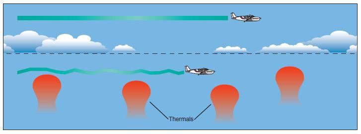
Convective activity can also chop the sky into columns of rising air (See Figure 2). This is perhaps the most common cause of turbulence, but it’s typically only problematic in summer at 18,000 feet or less AGL. Different surfaces reflect the heat of the sun unevenly and result in updrafts of varying strength. Deserts and high plains are the most obvious culprits, but thermals can present problems anywhere, and the very variability of the Earth’s reflective qualities helps to generate rough air. Glider pilots may actively seek out such strong free lift, but the updrafts can be major problems for pilots interested in a smooth ride.
Thunderstorms are a source of turbulence that most intelligent pilots will never have to deal with. That’s because few aviators fly anywhere near them. There’s nothing insidious about CBs (cumulonimbus clouds); the hazards are all too obvious – violent up and down drafts, icing conditions, hail, lightning, and even occasional tornados. They may not be nature’s automatic death machines, but any pilot who knowingly operates inside a fully developed cumulonimbus is asking to become a statistic.
CBs feed on heat, and they can grow to 40,000 feet in the mid-latitudes and 50,000 feet or more near the equator during a hot summer afternoon. (Darwin, Australia, is considered one of the world’s greatest thunderstorm incubators. In 1990, Darwin recorded a monster thunderstorm climbing to 72,000 feet. Not even Concorde could top that.)
Entire books have been written about thunderstorms, most of which offer the same advice – don’t go anywhere near them. Avoidance is usually a matter of climbing over or flying around. Over may not be practical, as a building thunderstorm may be able to outclimb you. Several years ago while flying a Cessna Conquest I across the Gulf of Mexico, I watched a CB building straight ahead at almost exactly the rate we were climbing. We finally gave up trying to top it and elected to go around the monster.
If you’re planning to circumnavigate a big storm, plan to fly around the right side, terrain permitting. All such storms manifest low pressure with counter-clockwise flow. If you go with the flow, you may actually realize a slight push.
Honeywell Laboratories is working on a new 3D radar system that will look as far as 60 miles ahead and indicate lightning, hail, and turbulence in real time. Previous radar systems only registered precipitation and became attenuated beyond the first wave of weather. The Honeywell system promises to provide early warning far enough out in front of the airplane to allow pilots to make intelligent deviations and smooth the ride.
For the present, turbulence remains mostly unpredictable, but there are some things a pilot can do to shortstop it. Several of the techniques are well-known and include the following:
• If your schedule will allow, fly as early in the day as possible, before the land heats up and sends thermals soaring into the middle sky, creating chop and generating cumulus clouds. Similarly, you can sometimes minimize the effect of thermal turbulence by flying as high as feasible. Most turboprops can manage altitudes in the low RVSM range, and much of the time, that should lift you above the chop. Even thunderstorms take awhile to build above 30,000 feet.
• Don’t be afraid to ask for help from the controller. Center may have reports of the ride ahead, and pilots flying the same track may provide early warning of the ride quality. Don’t be hesitant to jump on one of the air-to-air frequencies and ask any pilot out ahead of you about his flight conditions, even if he’s at a higher flight level. You may not be flying a Boeing 767, but most pilots will be happy to give you a weather update on the prevailing chop. If the ride becomes too rough, you can always ease power back to maintain Va (maneuvering speed) where no control movement can overstress the airplane. Also, don’t hesitate to report any significant turbulence to center so they can warn other pilots of the hazard.
• If your normal route takes you across the Rockies or Sierra Nevada — infamous breeding grounds for turbulence — you might consider rerouting to avoid direct overflights. You may be surprised at how little distance you’ll add to great circle routes. In transiting the US dozens of times in the flight levels, I’ve often crisscrossed both ranges, and I’ll sometimes route south over Santa Fe to avoid the rough air above Colorado.
• Finally, at the end of your flight, there’s always a possibility of wind shear, most often encountered at low level. Wind shear can be closely related to strong convective activity such as thunderstorms, but it may be generated by a number of other weather phenomena — topographical as well as meteorological. In its worst form, it’s a strong, often invisible downburst close to the ground, and it can be a very real hazard during approach.
The FAA does have Doppler radar installed at a number of airports around the country to monitor wind shear, but Doppler simply warns of current conditions near the ground rather than predicting future turbulence. A number of agencies are working on predicting wind shear, but that’s currently a future world.

