
Situational Awareness
The FAA’s Risk Management Handbook (FAA-H-8083-2) defines situational awareness or SA as “The accurate perception and understanding of all the factors and conditions within the four fundamental risk elements (pilot, aircraft, environment, and type of operation) that affect safety before, during, and after the flight.”
You may find that helpful … I don’t. To be helpful, you would need to look much closer at all the elements that go into a successful flight, whether it’s low risk, as in a local VFR flight, a Light IFR flight of say 300 miles in light weather, or a business flight to a client 500 miles away with weather concluding in an approach to minimums where the risk is significantly greater.
The “tools” we had available in 1972 when I started flying were so basic compared to today that it’s hard to imagine flying a VFR cross country with nothing but a single VOR, sectional chart on the knee, and basic dead reconning skills. There was no GPS with moving map, and your position was established by good preplanning, including highlighting points of interest on the map to look for enroute, such as airports, lakes, towers, and major structures. Situational awareness came when you found yourself flying over one of these and a sense of comfort followed. You were “situationally aware,” at least you knew your altitude and your position on the chart!
Your basic engine instruments told you that you were okay there, and you kept your head out of the cockpit looking for traffic. To say we have come a long way since then is an understatement. LORAN came along and gave us Lat and Lon and a direct heading to our destination, but it was a little unreliable and altitude sensitive. The portable GPS came along about 1997 and gave most of us our first moving map and electronic confirmation of our position.
Today, we see our exact position on a moving map either with a portable GPS, GPS navigator, or EFIS MFD or smart tablet and, thanks to ADS-B, most of the traffic that concerns us is presented to us in real time. While many of these tools were financially out of reach to the average GA pilot flying legacy Pipers and Cessnas, everyone had a portable GPS either as a primary VFR tool or as a backup tool in IFR. The “smart tablet” started making significant inroads into the GA cockpit in 2007.
Hilton Software was the first company to enter the world of “mobile aviation software” in 2003 with a focus on commercial and military markets and later introduced their WingX software for GA. Garmin entered the aviation software market with their Garmin Pilot app in 2012. Before I attempt to help a client with an avionics upgrade, I submit a questionnaire to them and ask about whether they use a smart tablet with aviation software in the cockpit. A few use WingX or Garmin Pilot.
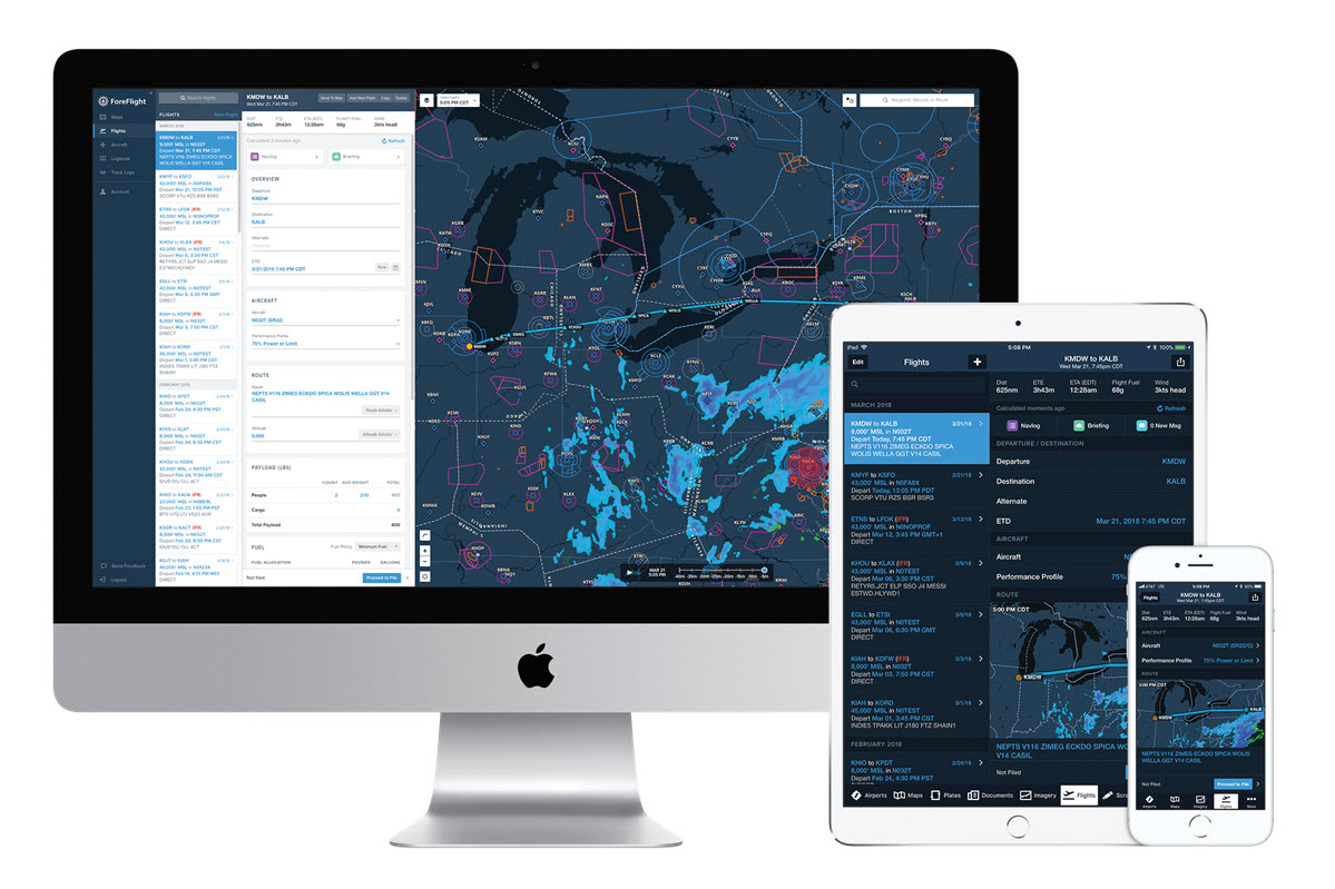
The bottom line is that most of my clients use ForeFlight on an iPad, so based on that, I’m comfortable in saying that ForeFlight is the dominant software and the iPad the dominant hardware being used in a GA cockpit today. With that in mind, I’ll go one step further. I don’t think in modern times another company has had a more significant effect on “situational awareness” in a Light GA aircraft than ForeFlight! So, based on that, let’s talk about ForeFlight.
ForeFlight
ForeFlight formed in 2007 with one guiding mission: Create software that makes flight planning easier. Since then, ForeFlight has not only revolutionized the pilot’s flight bag but also laid the groundwork to make mobile flight planning apps essential to flight operations.
ForeFlight Mobile, the company’s flagship product, is used by individual pilots and professional flight crews to gather weather and destination information efficiently. It has become the go-to app to route, plan, and file, access and manage electronic charts and maps, and organize flight publications. It’s also used as a reference for enroute navigation.
ForeFlight is a flight app that offers:
- Advanced flight planning capabilities
- Terminal procedure charts
- Enroute navigation charts
- Moving map with synthetic vision, hazard awareness, and weather information
- Aircraft performance profiles
- Customizable checklists
- Integration with certified avionics and portable ADS-B and GPS receivers
- A built-in documents catalog
- A pilot logbook
Let’s take a closer look at these features and benefits.
Flight Planning
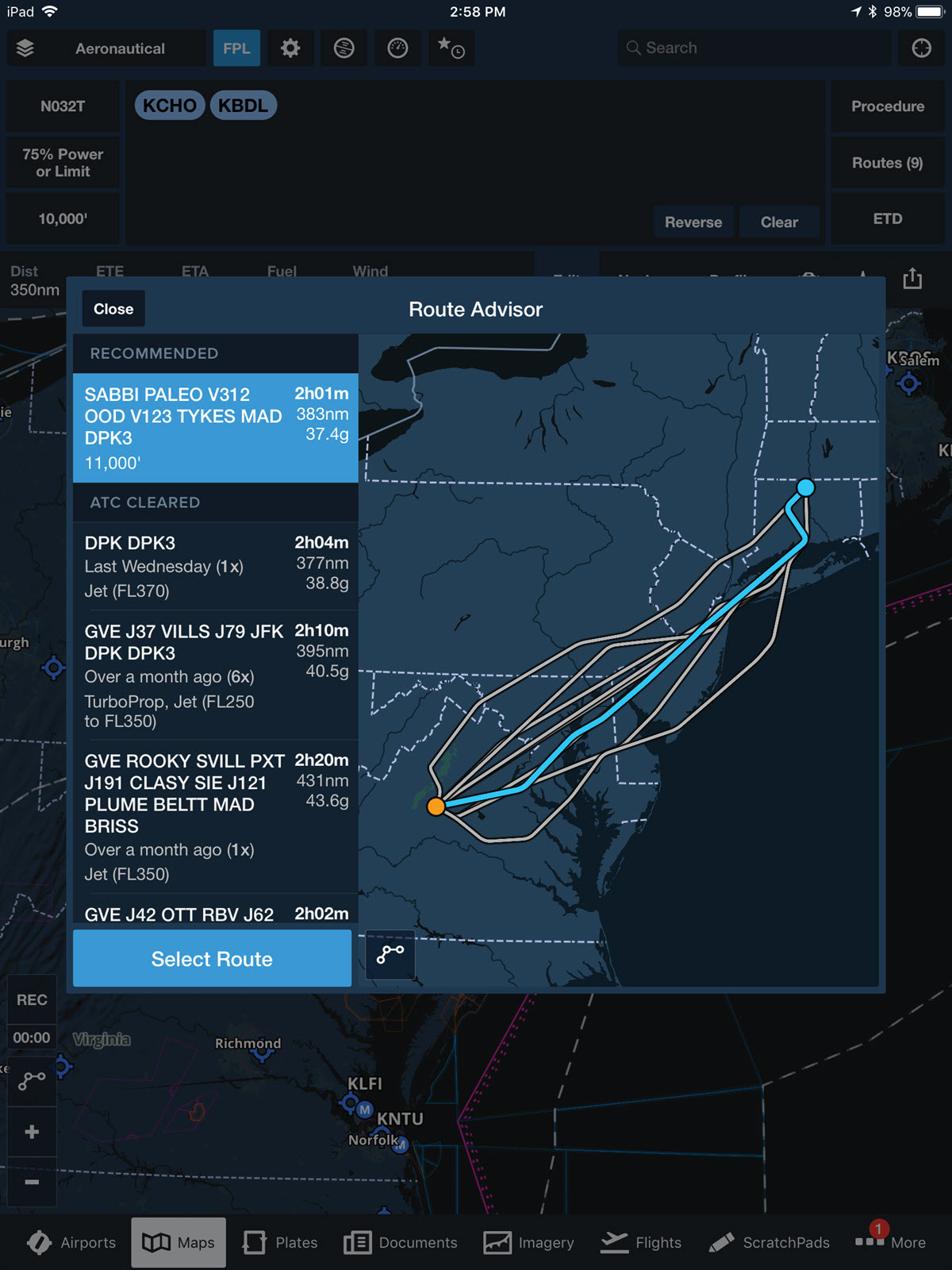
For starters, ForeFlight offers detailed airport information including frequencies, procedures, services, even current gas prices. ForeFlight’s route-search engine helps you locate the perfect destination or stopover. Route Editor and Navlog views allow you to easily add and rearrange items in your route and watch performance calculations (based on your aircraft’s performance data) update in real time. Rubber-banding is fully supported, and you can right-click to select from a list of nearby airports and waypoints. Route Advisor allows you to enter departure and destination airports and choose from a number of recent ATC cleared and preferred routes.
Charts
ForeFlight features aeronautical maps, VFR sectionals, high/low enroute charts, SIDs, STARs, approach and taxi charts, and terrain, satellite, and street map views.
The rest of this article can be seen only by paid members who are logged in.Have a website login already? Log in and start reading now.
Never created a website login before? Find your Customer Number (it’s on your mailing label) and register here.
JOIN HERE
Still have questions? Contact us here.


